Community Corner
Ring Around Ring Mountain
Early wildflowers and an easy walk on rolling grassland, with a rocky Irish feel. About two and a half miles. Dogs on leash. Hiking only on the loop trail.


Ring Mountain sits on the Tiburon peninsula with 360 degree views of the Bay Area. This open grassy hillside reminded us of grassy moors in Scotland or Ireland. We went to look for wildflowers, views, and unique petroglyphs from ancient native people. We were not disappointed.
We had heard of rare wildflowers that lived in the rocky serpentine soil of Ring Mountain from Kay Martin, author of Hiking Marin, and from internet sources. We kept our eyes peeled as we ascended from the Paradise Drive entrance up the Phyllis Ellman Trail. We took a left at the signed loop trail to run the circuit in a clockwise direction. The trail has numbered post markers, although figuring out which trail to take can be tricky. All trails seem to lead to the top however.
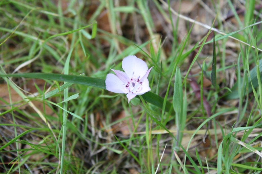
After crossing through grassy patches and shrubbery, the trail crosses several small streams covered by trees. There, nestled into the emerging grasses, was one of spring's first native wildflowers, the rare Oakland Mariposa Lily (Calochortus umbellatus). The flower is a delicate pink with a bright pink ring in the center and blue pollen on the stamens. It was the only one we saw, but as spring progresses there are bound to be more. Ring Mountain is also the only home of the Tiburon Mariposa Lily (Calochortus tiburonensis) that blooms later in spring. We will have to come back in May!
Find out what's happening in Larkspur-Corte Maderawith free, real-time updates from Patch.
The trail is alternately rocky and muddy, so bring your grubbiest shoes. Once on the ridge, the views are tremendous. San Quentin Penitentiary dominates the northern view, while the east bay hills and Mt. Diablo lie to the east. The views of the city to the south and Mt Tam to the west fill out the visual scenery. In the foreground, large hummocks of oaks and bays wrapped around huge serpentine boulders draw you to explore their protected nooks and crannies.
At the ridge line there are plenty of makeshift trails to rocks and trees. The peak of the mountain itself is a 602-foot high flattened plateau. In World War II the military razed the top to install heavy artillery as protection against invasion from the sea.
Find out what's happening in Larkspur-Corte Maderawith free, real-time updates from Patch.
Ring Mountain Fire Road follows the ridge. A huge boulder along the ridge, called Turtle Rock, is a popular bouldering spot for rock climbers. We could see the chalk marks along the east-facing side. Continuing to the intersection with the signed Phyllis Ellman Trail a sign on the left provides information about the open space. It is here that a trail and Reed Ranch Fire Road meander down to a fenced rock that contains engraved petroglyphs of the Miwok natives. Please respect these icons of past inhabitants and look only. There has been much vandalism of these prehistoric remains.
The hike off the ridge on the Phyllis Ellman Trail is muddy in spots and, although you are supposed to follow the numbered wooden posts, finding them is not always easy. We kept up the quest for wildflowers, spotting milkmaids, buttercups, yarrow, and irises. This unique habitat is a special place, worth a visit this week.
See the book "Hiking Marin: 141 Great Hikes in Marin County" for more details. Click here to go the Marin Trails website, where you can find more information about the book.


